Mind the Spelling
Keep an eye out and you will spot "Wedgewood" with an extra e on some business signs and even on an unofficial city map. The correct spelling has no middle e. Developer Albert Balch named the area after the English bone china maker Wedgwood, which was his wife's favorite.
Big Rock, the Oldest Landmark
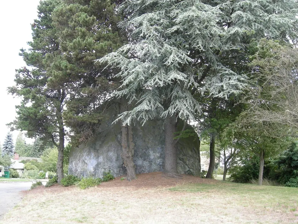
Head to the Wedgwood Rock to see what was here long before any houses went up: a glacial erratic, a boulder left behind by retreating ice. It stands about 19 feet tall and measures roughly 75 feet around. Back when dense old growth forest covered the land, several trails met at this very rock.
The ancestors of today's Duwamish tribe, Lushootseed-speaking Coast Salish people, used those trails as they hunted and traveled through the area. People have lived in this landscape since the end of the last glacial period, around 10,000 years ago. The boulder was spared from housing development in 1941, and the neighborhood has embraced it ever since.
From Ginseng Farm to Neighborhood
The heart of Wedgwood, west of 35th Avenue NE between 80th and 85th Streets, began as a 40-acre wooded tract owned by Charles E. Thorpe. He grew ginseng there and built a log cabin from his own trees. As utilities and new businesses arrived in the 1920s, Thorpe decided the area had grown too urban.
Seattle University, a Jesuit school, bought his land in 1929 for $65,000, hoping to move its campus north from First Hill. A month later the stock market crashed, and the Depression stalled those plans. By 1940 the Jesuits sold the still-forested land to Balch for $22,500, about a third of what they had paid.
The Cabin That Became a Parish
Thorpe's cabin found a second life in 1929 as St. Ignatius Parish, served for years by visiting priests. The congregation kept growing and eventually became Our Lady of the Lake, which moved to 35th Avenue at 89th Street NE around 1961. A Catholic presence has remained in the neighborhood ever since.
Wartime Cape Cods
Major building began during World War II, when defense workers needed housing. Balch and his partner Maury Setzer put up about 500 homes on those 40 acres, and they still form the center of Wedgwood today. The architecture firm Thomas, Grainger and Thomas designed them in the Cape Cod style, possibly a nod to Balch's New England ancestry.
Each house was built a little different from its neighbors, and each originally sold for $5,000. Many have since been updated and expanded, yet the steep roofs and tidy proportions still give these blocks a distinct character. Stroll through the core streets for the easiest look at the neighborhood's founding vision.
A Volunteer Fire Department Run Partly by Women
Seattle's city limits stopped at NE 65th Street back then, so Wedgwood had to look after itself. In November 1943, residents formed a volunteer fire department, running a Ford Model A pump truck out of a home garage, and many of the volunteers during the war years were women. The city absorbed Wedgwood, fire district and all, in March 1945.
Gardens and Green Space
For visitors, the open spaces are the real draw. City of Seattle records list Dahl Playfield and Inverness Ravine Park in the area, along with the historic Picardo Farm site. For more green spaces across the city, check our Seattle parks guide.
Picardo Farm and the First P-Patch
The Picardo family farmed land near the neighborhood's western edge from 1922 until 1965. In the mid-1960s, part of that land became Seattle's first community garden, and it is still the largest. The "P" in P-Patch, now the name of the whole citywide program, originally stood for Picardo.
University Prep School and Temple Beth Am, a Reform synagogue, sit beside the garden on former farmland. Gardeners and curious walkers alike can spend a moment here, where a beloved Seattle tradition began.
Dahl Playfield and Its Burning Bog
Just south of the old farm, Dahl Playfield covers land that was once a peat bog known as the Ravenna Swamp. Homes stood on part of it in the 1940s, but after sewer lines went in along 25th Avenue NE, those houses began sinking into the soft peat. The city bought them out to create a playfield.
Then, in 1952, the bog itself caught fire. Some sections sank as much as five feet, and the park closed for a time while crews swapped roughly 75,000 cubic yards of peat for fill dirt. It reopened and in 1955 was renamed for Waldo J. Dahl, a former Park Board director, and the Wedgwood Community Council formally adopted it in 1992.
Maple Creek's Ravine
In the 1930s, Dr. and Mrs. Philip M. Rogers bought 15 acres between 40th and 45th Avenues NE, where Maple Creek cuts a ravine. They left it nearly wild for years and let it serve as a Boy Scout camp. Development finally arrived in the 1950s, but the ravine landscape still shapes this part of the neighborhood.
The Jolly Roger and Prohibition Days
Washington went dry in 1916, and speakeasies soon sprouted along the roads leading out of the city. One of the most famous stood on what is now Lake City Way. First called the China Castle and later the Jolly Roger, it had a tower where a lookout could spot approaching police from far away.
Tunnels, including one under the highway, let patrons slip into a wooded ravine during raids. The building later thrived as a dance hall and restaurant and became a Seattle Historic Landmark in 1979. An arson fire gutted it in 1989, the cause was never solved, and it was torn down in 1991; a gas station now occupies the site. Discover surviving historic sites in our Seattle landmarks guide.
Living in Wedgwood
Wedgwood has long been known as a middle-class area of single-family homes. In 2001, the Seattle Housing Authority bought the Wedgewood Estates apartment complex on NE 75th Street to help keep moderately priced housing available in this part of the city. If you are researching rentals, contact the Seattle Housing Authority or current property managers for up-to-date information.
For shopping and dining, head to Wedgwood Square and the commercial blocks of 35th Avenue NE. Businesses change, so check directly with any shop or restaurant for current hours before you set out.
Plan Your Half Day
Spend a good half day here: take in Big Rock, wander the Cape Cod core, then finish with time at the P-Patch and Dahl Playfield. Round out the trip with nearby attractions from our list of things to do in Seattle. For park rules and facilities, Seattle Parks and Recreation is the best source for current details.