Driving in over Agate Pass
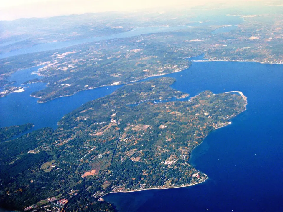
If you come by car, your only road link is State Route 305, which crosses the Agate Pass Bridge at the island's northwest corner. That route ties Bainbridge to the Kitsap Peninsula, Poulsbo and the Suquamish Indian Reservation. Bremerton sits close by across the water to the southwest, though islanders have long resisted building a bridge in that direction.
How Winslow Grew Into the Whole City
Winslow grew slowly beside the busy mill towns at Port Madison and Port Blakely. Its story follows a harbor village that kept gaining weight until it absorbed everything around it.
From Madrone to Winslow
In 1878, a Kansas settler named Riley M. Hoskinson made his home on Eagle Harbor, in a settlement then called Madrone after the island's madrone trees. He kept an informal weather station that served as the area's only weather record for about 12 years. A one-room school followed in 1881, and the Eagle Harbor Congregational Church came along in 1882.
Everything shifted in 1902, when the Hall Brothers Marine Railway and Shipbuilding Company moved over from Port Blakely. Company president Henry Knox Hall helped rename the town Winslow in memory of his late brother. Shipbuilding brought fresh growth, along with community halls and theaters that could seat crowds of a couple hundred.
A homegrown ferry
Around 1900, residents who wanted a dependable link to Seattle sold shares to build their own wood-fired steamer, the Eagle. It served the town proudly until August 1902, when it burned at the dock. The community replaced it with the Florence K, an early sign of how closely the island's identity was tied to the same water crossing you make today.
Cityhood by a thin margin
Winslow voted to incorporate in 1947, when it had 905 residents, and the measure passed by just 12 votes. The young city became known for lively Fourth of July celebrations and offbeat parades. Another close vote in 1990 and 1991 let Winslow annex the rest of the island, and on November 7, 1991, the city officially took the name Bainbridge Island.
Older Stories Across the Island
Suquamish homelands
Long before Winslow, the Suquamish people and their ancestors lived here for thousands of years. They kept nine villages on the island, with winter sites at Port Madison, Battle Point, Point White, Lynwood Center, Port Blakely and Eagle Harbor. Under the Point Elliott Treaty in 1855, the tribe ceded its territory in exchange for a reservation at Port Madison and fishing rights in Puget Sound.
Explorers and a name
Captain George Vancouver anchored HMS Discovery off Restoration Point in 1792 and named the point for the English Restoration. He missed Agate Passage, so his charts showed the island as a peninsula. The expedition led by Charles Wilkes found the passage in 1841 and named the island for Commodore William Bainbridge of the USS Constitution.
The Japanese American Exclusion Memorial
Japanese immigrants began arriving in 1883 and became part of island life. During World War II, Japanese American residents of Bainbridge were the first sent to incarceration camps, where they were held for the rest of the war. Set aside time for the Bainbridge Island Japanese American Exclusion Memorial, which opened in 2011 to honor them. A new visitor center was dedicated in fall 2026, with survivors cutting the ribbon, and the site stands among the most meaningful historic landmarks in the Seattle area.
Shoreline, Hills and Road Ends
Shaped by the Vashon Glacier during the last ice age, the island runs roughly 10 miles long and 5 miles wide. Follow its coastline of about 53 miles and you find bays, spits, bluffs, lagoons, tide flats and rocky points. The highest ground is Toe Jam Hill, which rises to 425 feet.
Restoration Point, at the southeast tip, was once seabed until an earthquake roughly 1,100 years ago lifted it about 23 feet. All around the island, small public access points called Road Ends let you reach the shore without crossing private property.
The terrain is hilly enough to anchor the Chilly Hilly bicycle ride each February. If you plan to cycle, expect real climbs once you leave the flat ground near the ferry.
Who Lives on Bainbridge
The 2020 census counted 24,825 residents, making Bainbridge the second largest city in Kitsap County. The median age was 50.7, with about a quarter of residents 65 or older. Since the 1960s, the island has grown into a well-off commuter community for Seattle.
Winslow looks different from the rest of the island. Incomes here span a much wider range, and more than half of households rent, compared with about a fifth islandwide. That mix gives the town center a busier, more everyday feel than the quiet rural roads beyond it.